With increasing adoption of drones within public safety agencies, a significant change is happening—the emergence of Drone as First Responder (DFR) programs. Setting itself apart from conventional drone deployments, the DFR approach has gained momentum, signaling a larger shift in the dynamics of emergency response. This article goes into depth about DFR programs, exploring their role in boosting efficiency, tackling staffing constraints, and enhancing de-escalation.
Defining Drone as First Responder Programs
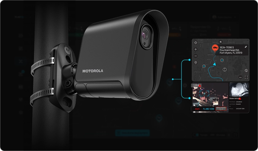
DFR programs redefine emergency response by strategically deploying unmanned aerial vehicles (UAVs) to respond to emergencies. Unlike traditional deployments, where drones are launched after responders arrive, DFR programs position drones at fixed locations to respond immediately upon receiving calls for service.
Drone as First Responder (DFR) programs represent a paradigm shift in emergency response strategies, harnessing the strategic deployment of unmanned aerial vehicles (UAVs) to rapidly respond to a spectrum of emergencies. These DFR programs redefine traditional response mechanisms by leveraging the unique capabilities of drones to enhance situational awareness and provide crucial insights before first responders arrive on scene.
The Need for Innovation in Emergency Response
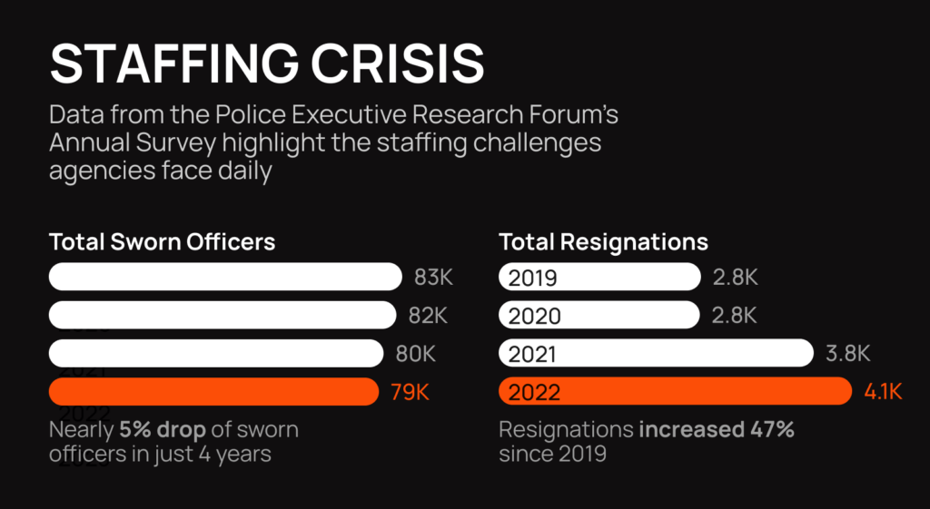
Staffing Constraints and Workload Challenges:
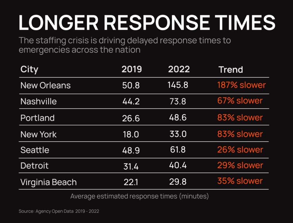
Law enforcement agencies in the modern era grapple with substantial staffing constraints and escalating workloads. The demand for police services has increased over the years, placing an immense burden on existing resources. The shortage of personnel and the corresponding increase in responsibilities strain the capacity of traditional emergency response systems. As a result, law enforcement agencies often find themselves stretched thin, struggling to maintain timely and effective responses to incidents.
Prolonged Response Times:
The inherent challenges of law enforcement, coupled with staffing constraints, contribute to prolonged response times. Addressing these delays is critical to enhancing public safety and ensuring the timely resolution of incidents. Drones present a solution that can overcome the limitations of ground-based units and significantly reduce response times in emergency situations.
Calls to Rethink Police Response and De-escalation:
In the current socio-political landscape, law enforcement agencies face growing calls for a change in response tactics and a heightened emphasis on de-escalation strategies. Communities are advocating for a shift in policing methods, seeking alternatives to use of force and promoting community-centric approaches. The evolving expectations from the community necessitate innovative tools and methodologies that align with the principles of de-escalation while maintaining public safety.
Time Sensitivity in Emergencies:
Time is of the essence in emergency situations. Seconds count. Whether it’s a search and rescue mission or a medical emergency, delays in response time can directly impact the outcome. Traditional emergency services, constrained by factors like traffic congestion or the need for physical routes, may struggle to meet the urgent demands of certain crimes in progress. Drones, being airborne and equipped with advanced navigation systems, offer a solution that can significantly reduce response times.

Unpredictability of Emergencies:
Emergencies are inherently unpredictable, and the dynamic nature of these situations requires a response system that can adapt quickly. Drones, with their agility and versatility, provide a flexible solution that can be deployed rapidly to assess the evolving circumstances. Whether it’s a natural disaster, a fire, a shooting or a medical crisis, the unpredictable nature of emergencies demands innovative solutions that can swiftly and effectively address emerging challenges.
The Solution is DFR
Enhancing Situational Awareness:
Drones equipped with advanced sensors, cameras, and real-time communication capabilities enhance the situational awareness of law enforcement officers. This heightened awareness allows officers to make informed decisions during emergencies, potentially de-escalating situations through a better understanding of the environment. Additionally, the aerial perspective provided by drones can aid in assessing the severity of incidents before ground units arrive, optimizing resource allocation.
Complementing Traditional Response Methods:
While drones offer innovative solutions, they are not intended to replace traditional response methods. Instead, they complement existing strategies by providing a rapid and aerial perspective that enhances the overall effectiveness of law enforcement agencies. The integration of DFR aligns with the broader objectives of improving response times, increasing situational awareness, and promoting community-centered approaches in line with the evolving expectations of the public.

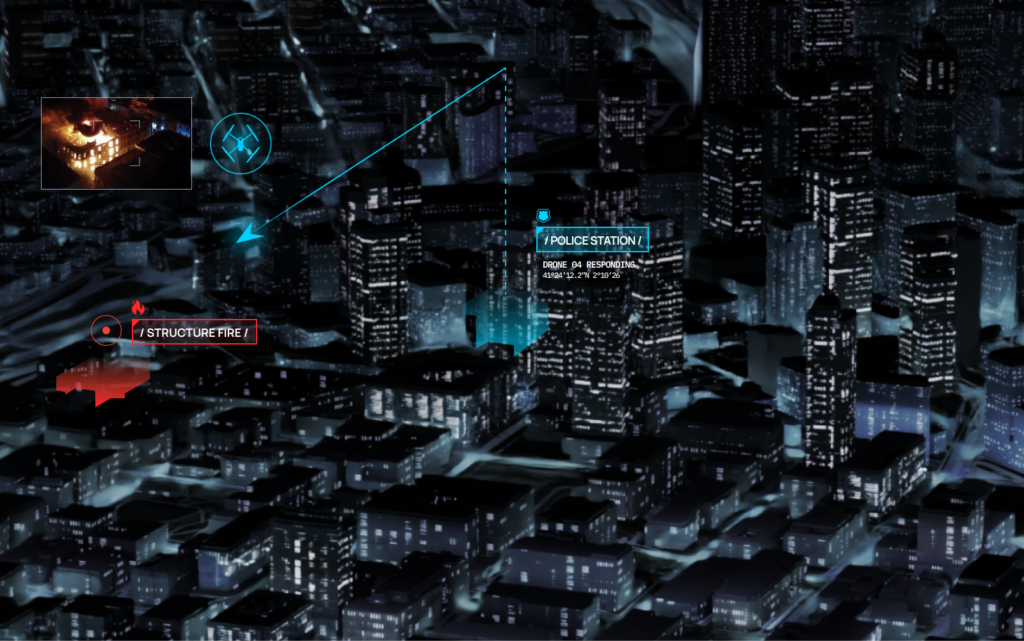
Emergency Incidents for Drone as First Responder
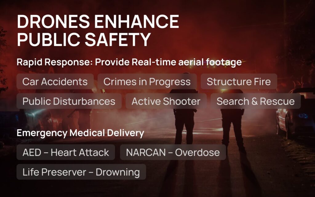
Crimes in Progress
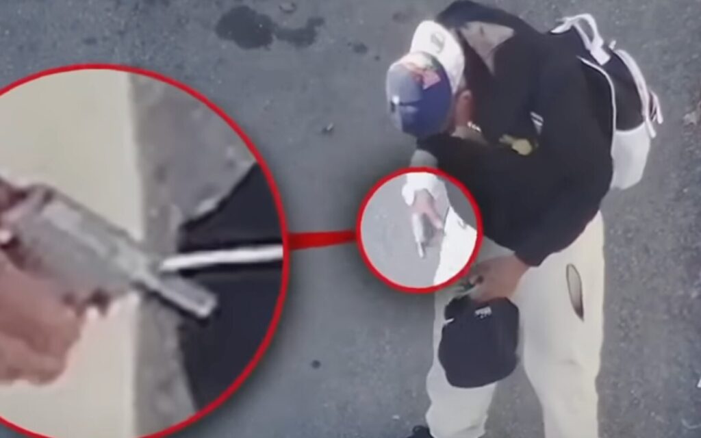
Responding to crimes in progress demands quick yet cautious action from police. When arriving on scene officers must gather information, identify suspects, and assess potential threats while prioritizing safety. They rely on limited updates from dispatchers and observational skills to evaluate the situation upon arrival. With DFR, a drone is able to gather information about the scene, identify suspects, and assess potential threats without putting officers in immediate danger.
Traffic Accidents
When responding to traffic accidents, the severity can vary. DFR offers a swift and efficient means to reach the scene and swiftly survey the accident site, capturing crucial information about the extent of damage, potential injuries, and any hazardous conditions present, providing valuable data to inform their response strategy.

Emergency Payload Delivery
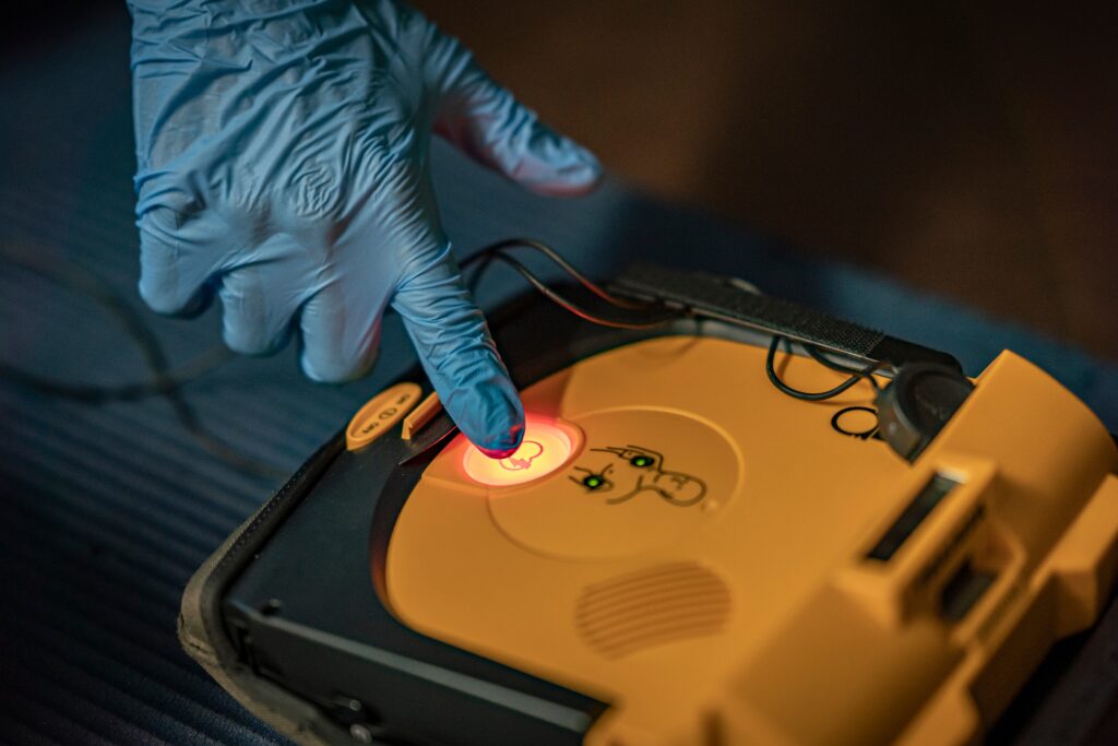
Emergency payload delivery plays a crucial role in providing life-saving assistance in critical situations, such as delivering vital supplies like an Automated External Defibrillator (AED) to someone experiencing cardiac arrest. Utilizing aerial assets equipped with payload delivery capabilities, emergency responders can rapidly transport essential equipment to remote or inaccessible locations where time is of the essence.
Active Shooter
In the realm of active shooter response, drones serve as invaluable tools, providing real-time visual information to responding officers. By offering a bird’s-eye view of the scene, drones enhance situational awareness, enabling more informed decision-making and strategic deployment of resources.
Conclusion:
In an era defined by staffing constraints, increased workloads, long response times and a call for police reform, the need for innovation in emergency response is more pronounced than ever. Drones as first responder has emerged as a transformative solution, equipping public safety agencies with the tools needed to navigate the complexities of community safety. By embracing technological advancements, agencies can enhance their public safety capabilities, mitigate challenges, and work towards a more efficient and responsive approach to ensuring public safety.
Don’t let spotty cell service doom your drones
Relying on cell service for your agency’s drone operations is just fine and dandy – until there’s unreliable cell service. And there are many parts of America, both rural and near major metropolitan areas, where cell service is spotty at best.
No problem, just rely on radios. But depending on radio connectivity for drone operations poses its own challenges, as signals tend to drop near large structures and you’re tied to remote controllers.
So how can emergency responders fly a drone without reliable reception?
Pair cell and radio systems together with the BRINC Connect blended communication system to get the benefits of each while adding redundancy and flexibility.
Not only can agencies enhance operational uptime but you can also customize communication and streamline emergency response by ensuring seamless integration of all systems – BRINC Pilot, LEMUR 2 drone, Responder drone, and BRINC LiveOps software platform.
Industry-Leading Tech to the Rescue
The system revolves around cutting-edge meshing radio technology to increase spectral efficiency and deliver a robust, reliable communication link to BRINC Connect.
By embedding this innovative radio technology into the BRINC Pilot controller and all our drones, we offer a seamless communication framework across platforms.
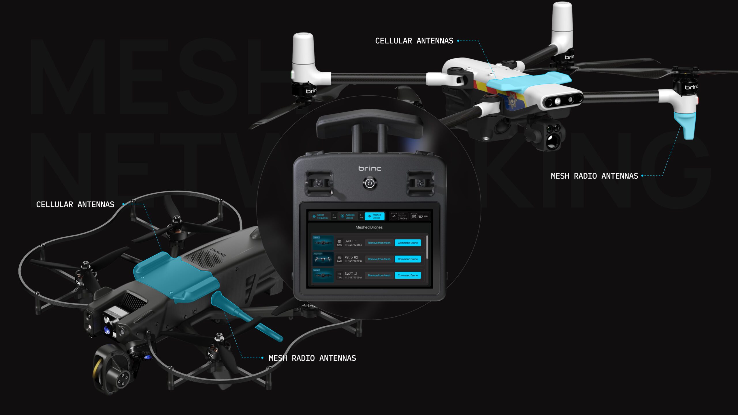
“With the integration of state-of-the-art radio systems and our fusion of radio and 4G LTE modems, BRINC Connect brings an unmatched level of communication and interoperability to the industry,” said BRINC founder and CEO Blake Resnick. “This system empowers first responders to access real-time data, operate our drones from greater distances, and communicate effectively during critical incidents.”
Drone to Drone Comms
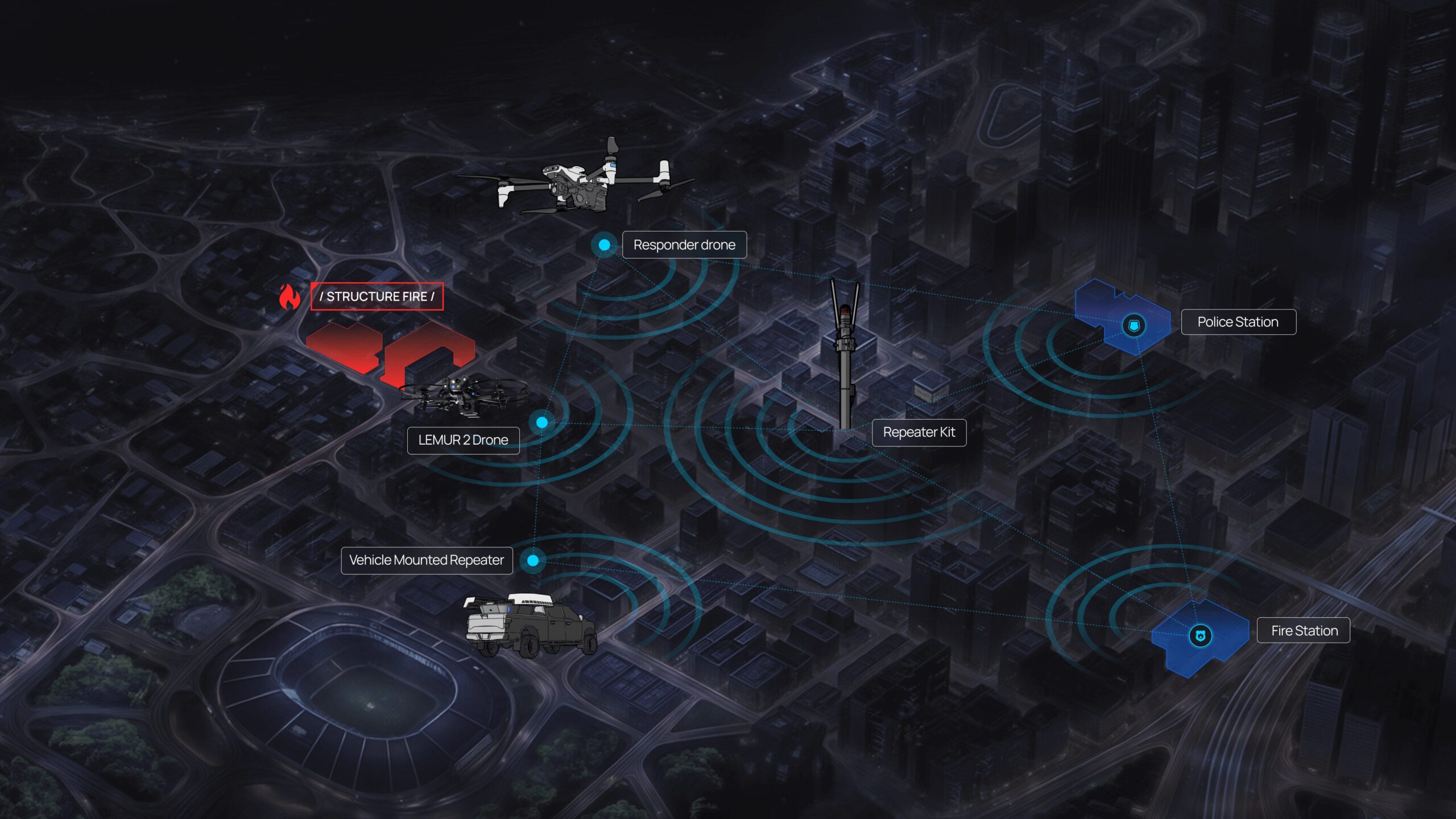
One of the main advantages of meshed communications is that information passes not only from controller to drone, but also from drone to drone, extending operational range. Which means communications become more reliable and performative as you deploy more BRINC technology on-scene.
This drone-to-drone communication becomes invaluable for indoor drone operations, where concrete buildings can quickly block out both radio and 4G LTE signals. According to Will Huddler, BRINC VP of Customer Success and Training and former SWAT Commander for the Las Vegas Metro PD, “customers encountering a challenging radiofrequency environment while clearing a building, send the first drone just inside and perch it, starting the mesh network and covering a critical area. Then they’ll deploy a second Lemur 2 to enter further into the structure.”
This meshed communication becomes even more beneficial when combining the capabilities of an interior drone like the BRINC Lemur and an outdoor drone such as the BRINC Responder. Whereas it can be hard for signals to penetrate thick concrete walls of a (school) building, an interior drone can easily mesh with a drone overhead.
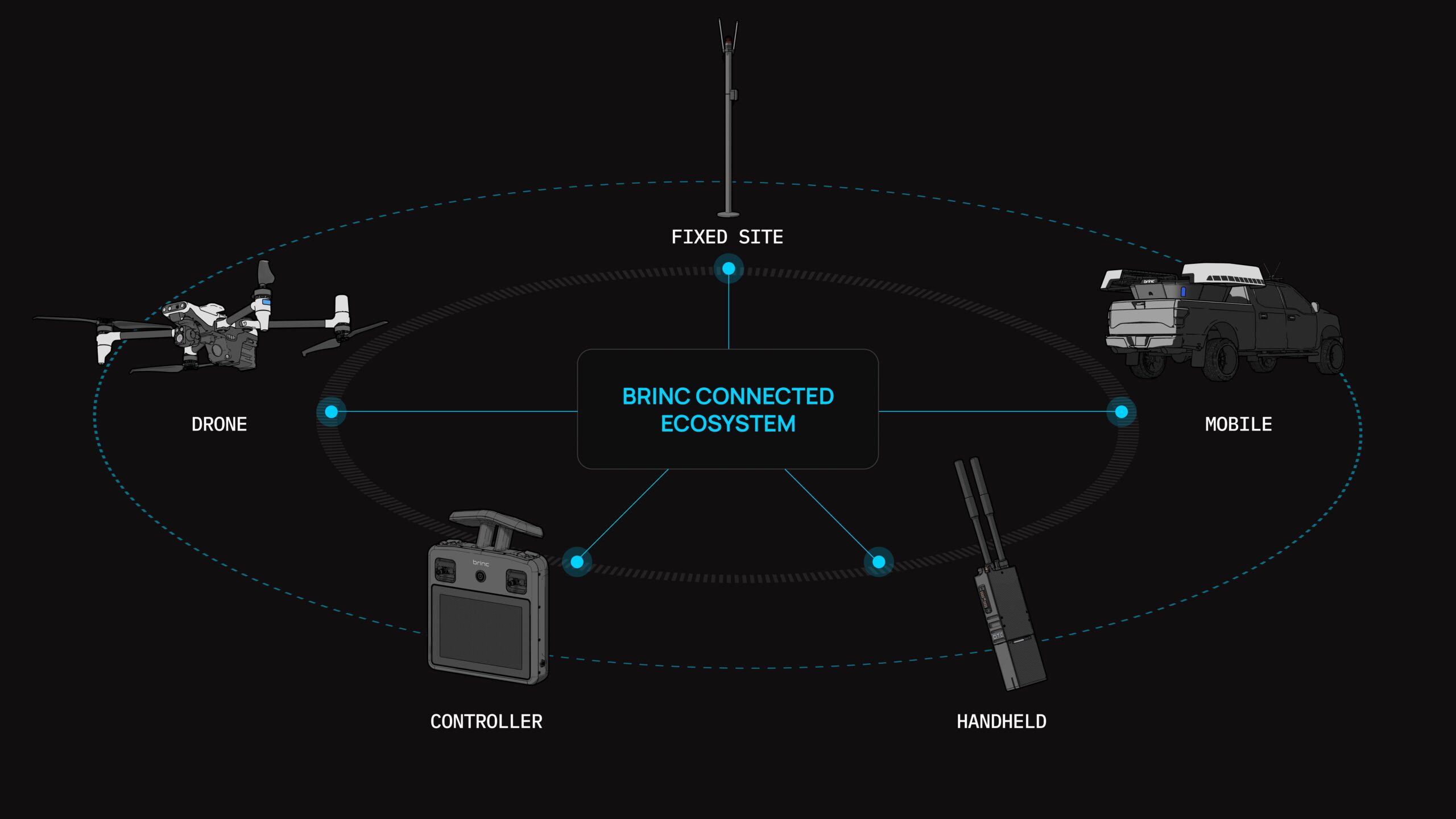
Handheld. Fixed. Mobile.
For agencies with diverse needs and geographic challenges, BRINC Connect can include custom repeater kits that leverage software-defined radios so you can customize frequency ranges based on your jurisdiction’s needs.
For SWAT and manual deployments, our tactical repeater kit can strap to an officer’s vest or be placed wherever it’s needed.
For agencies with a lot of ground to cover, vehicle-mounted repeater kits allow you to scale out your connectivity across the whole jurisdiction.
And finally, the fixed-site kit allows you to solve known radio interference problems and boost capacity.
If your agency would like to learn more about upgrading your drone fleet, contact us here.
Less DIY. More Fully-Integrated Mounting Systems.
Nine years ago, drones were a relatively new phenomenon especially within public safety. If first responders had access, they had to be creative, piece-mealing consumer drones together to execute rescue operations.
Take Joshua Fire Department volunteer Garrett Bryl, for example, who flew his personal quadcopter (nicknamed Valkyrie) during the 2015 Johnson County, Texas, flash floods. With the Kastel family trapped in their mobile home by flood waters, Bryl attached a rope to Valkyrie and flew it over to the Kastels, who attached it to a beam on their house. Rescue workers then used that rope to send over life preservers before airlifting the family to safety in a helicopter.
“Knowing that we had life vests and a safety line made a huge difference,” Kastel told People Magazine. “Watching that drone come in was the coolest thing I’d ever seen.”
It’s a great early example of how drones can save lives during rescue operations. But what if we could take some of the spontaneous ingenuity out of it? What if public safety drones came custom-equipped with outfitting that could easily deploy specific payloads? First responders would no longer lose precious time jerry-rigging their drones to save lives––purpose-built technology could free up time to save even more lives.
At BRINC, this is what we’ve been working on as we’ve engaged public safety teams across America and received feedback on their ideal 911 drone response system.
“When drones deliver emergency medical payloads, they don’t just benefit public safety departments but the community as a whole,” says Don Redmond, retired police captain and BRINC VP of Public Safety. “There’s a huge benefit to having these public safety drones standard equipped with lifesaving tools.”
Critical Deliveries Save Lives
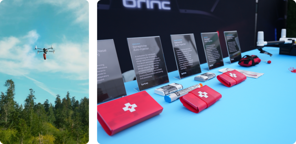
The goal at BRINC is simple: engineer a seamless way for public safety agencies to operationalize emergency medical deliveries. So first responders can rapidly deploy drones during emergencies, and pre-mounted medical devices can arrive within 70 seconds. In critical situations, like an overdose, drowning or a heart attack, that’s the difference between positive and negative outcomes.
In the case of the Johnson County flash floods, first responders wouldn’t have had to rely on a rope hastily tied to a personal quadcopter because an Emergency Flotation Device (EFD) would’ve already been mounted on their drone.
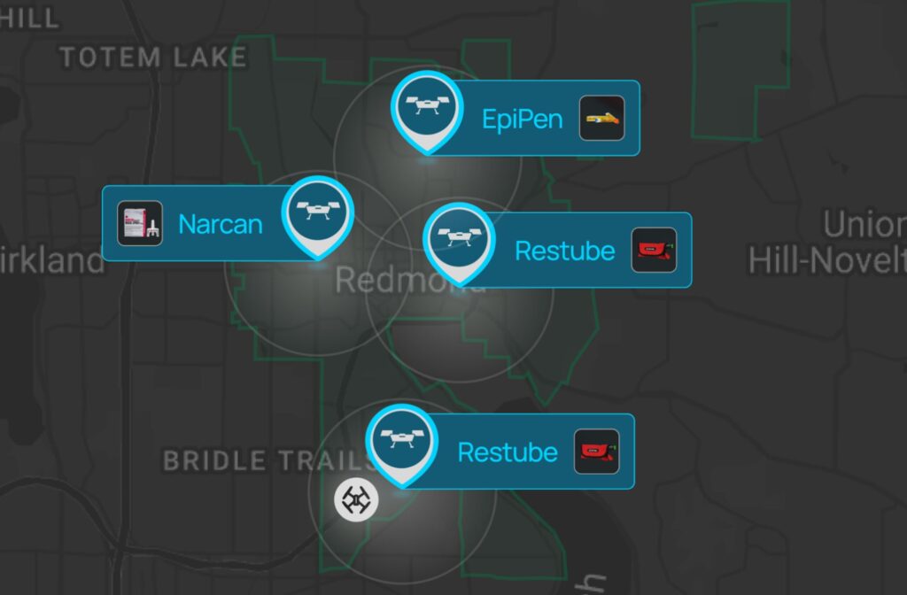
Or should someone in the backcountry suffer a medical emergency—be it an overdose, injury or an anaphylactic reaction—first responders could provide life-saving supplies with drones mounted with Narcan, trauma kit, or EpiPens.
Now imagine if first responders were able to drop an Automated External Defibrillator (AED) in a remote location and jumpstart the heart of someone going through cardiac arrest. Or drop Glucagon to a hiker experiencing a diabetic emergency.
BRINC Responder drones not only have the capacity to save lives by delivering these medical devices, but they also have two-way communication so operators, pilots, or dispatchers can talk to victims in times of distress when the payload is delivered. Should a good samaritan need help administering the Narcan or EpiPen dropped from a Responder drone, clear directions and assurance can be provided in real time.
To make these emergency medical deployable payloads a reality, BRINC is in the process of partnering with companies behind life-saving payloads such as EFDs, Narcan, AEDs, EpiPens and more.
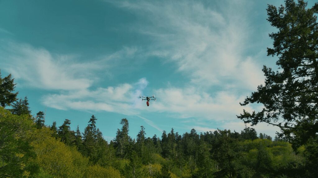
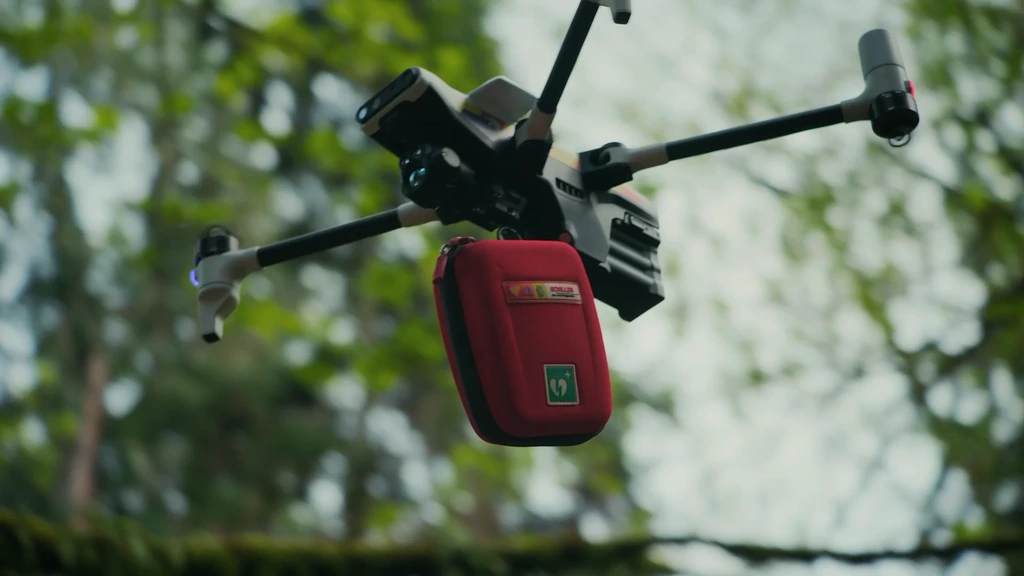
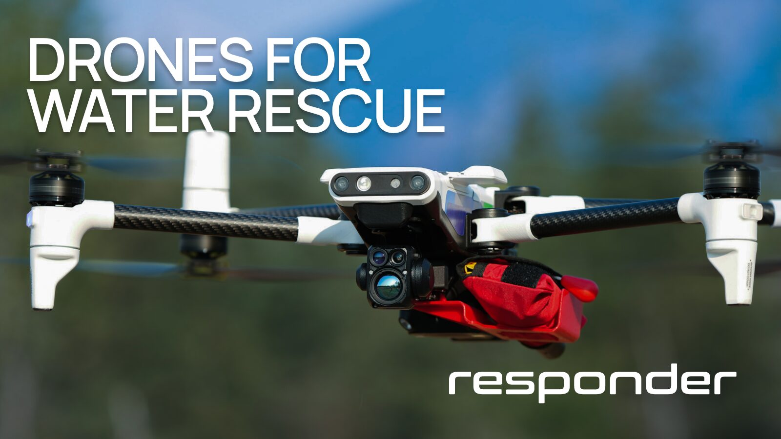
One such example is our recent partnership with Omada Group to provide easily deployable Restube EFDs to first responders. These lightweight Restube EFDs deploy automatically when they hit water and provide 75N actual buoyancy.
Custom Outfitted for Specific Agency Needs
Every agency has unique needs, so it’s important to understand which payloads will be the most useful. An agency that deals with a high frequency of water rescues will need more Restube EFD mounts, while one that’s in the heart of the opioid crisis will most likely prefer mounts for Narcan.
As the BRINC team works with agencies to identify fixed launch locations for their Drone as First Responder programs, we collect data on the types of callouts throughout their jurisdictions. This has proven insightful when determining which medical payloads should be mounted 24/7 at each of the sites.
Easy Mounts for Manual or Automated Deployment
Whether the emergency medical deployment is manual or automated, the mounting process must be fast and easy to save valuable time and maintain the drone’s maneuverability.
The goal is for medical payloads to tuck snugly against the side of the drone’s airframe for maximum efficiency. BRINC’s medical device mount has minimal impact on launch and drone operations. It also remains attached even when the drone is housed within its robotic charging nest.
“If you attach something randomly to the drone, it could get eaten by the props, throw off the weight, or fall on someone,” says Tom Luce, Principal Mechanical Design Engineer at BRINC. “Our mounts are much more secure and intentional to reduce risk and streamline operations during a time-sensitive emergency.”
Payload Effects on Flight Time
Of course, the weight of a drone’s payload affects its flight time, but due to the lightness of auto-injectors, Narcan, and the Restube Automatic EFD, there’s a relatively small impact on flight time.
“The goal is to minimize weight and enable the drone to land with the payload still attached,” says Luce. “Basically, we want to fly the drone and still have control of flight time and balance.”
The below chart correlates payload size and impact on flight time with the BRINC Responder drone. The Restube Automatic will decrease flight time by around 4-5 minutes. The upcoming Restube Automatic Pro will be closer to 8 minutes of diminished flight time.
BRINC Responder Flight Time with Different Payloads

A Prepared Drone is a Lifesaver
In an emergency, speed, and preparedness matter. Public safety drones that come custom-equipped with mounts for emergency payloads save communities time and lives. Contact a BRINC representative to outfit your jurisdiction with drones and emergency deployable payloads here.
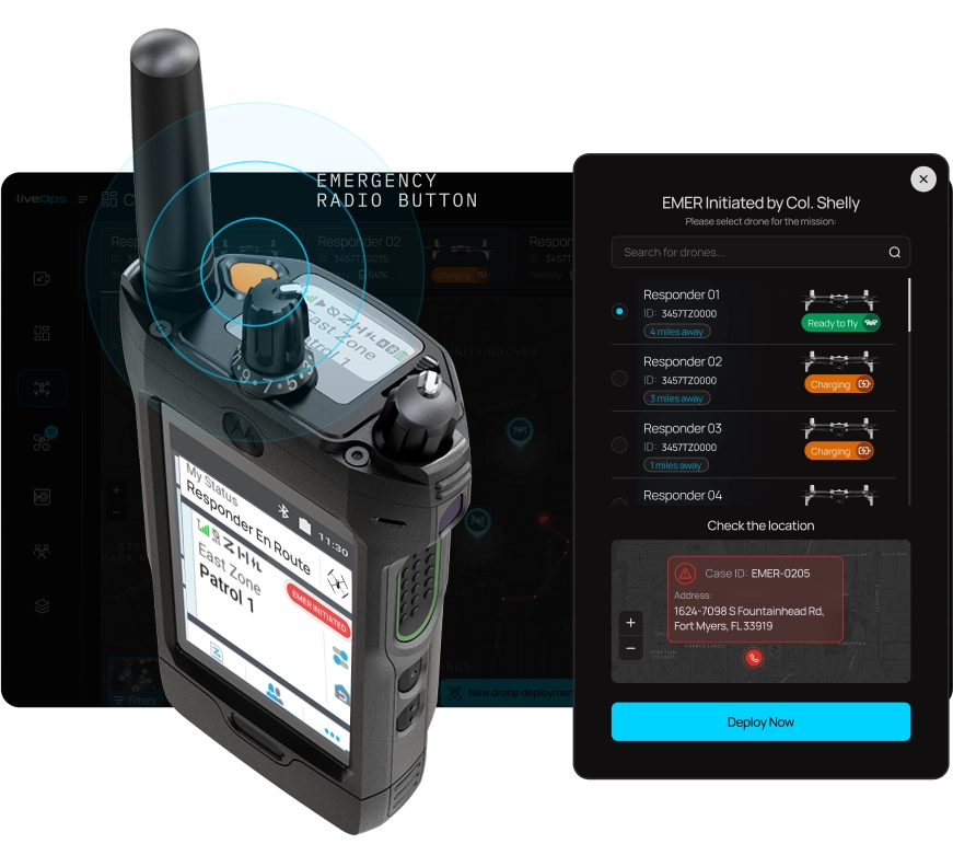
Today, we’re thrilled to unveil the first ever end-to-end Drone as First Responder (DFR) solution with the Responder drone and Responder Station automated charging nest. This integrated platform seamlessly links with 911 and Computer-Aided Dispatch (CAD) systems to enable the autonomous deployment of drones to 911 calls and other emergencies.
The First End-to-End DFR Solution
Previously, DFR operations have relied on general-purpose drones, a variety of 3rd party software products / accessories, and incomplete integrations. Responder, Station, and LiveOps represent the first solutions purpose built for public safety DFR operations. This focused approach has enabled us to make a wide variety of mission-specific decisions, making the BRINC DFR solution the most integrated, capable, and easy to implement solution to date.
Table of Contents
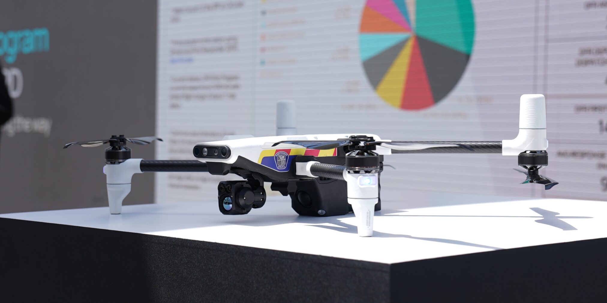
Identifiable During an Emergency
Responder is an emergency response vehicle, not your everyday gray consumer drone. With integrated emergency lights, customizable agency markings and a siren this drone was built to be quickly identified.
Operate From Anywhere
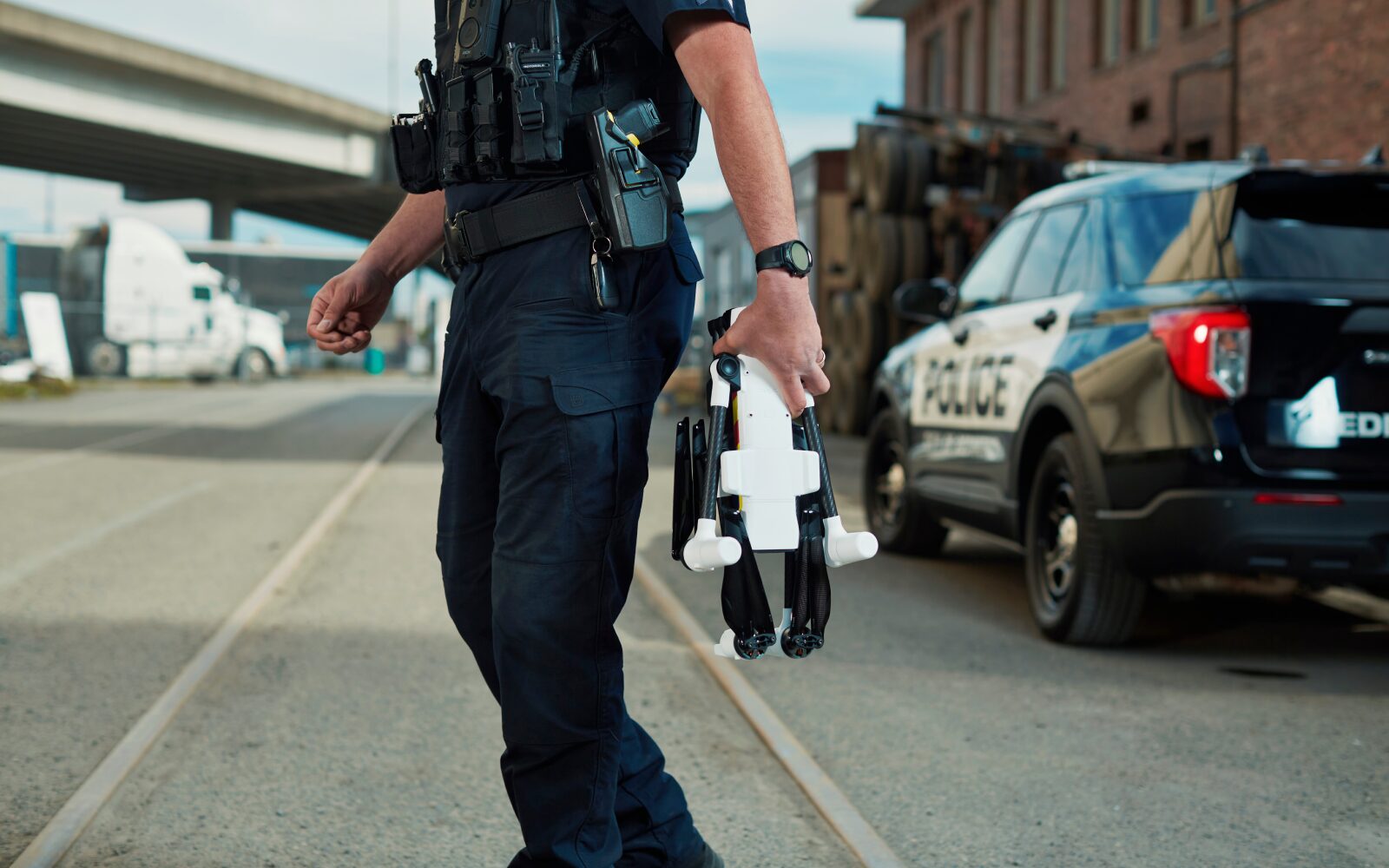
Responder is multifaceted, supporting first responders as an agency’s automated DFR drone, as a patrol-led DFR bird, or as a manually deployed drone.
In addition to its versatile deployment options, Responder has an integrated 4G LTE modem that allows for both live video streaming, and full teleoperation, in other words drone flight from a laptop, from anywhere.
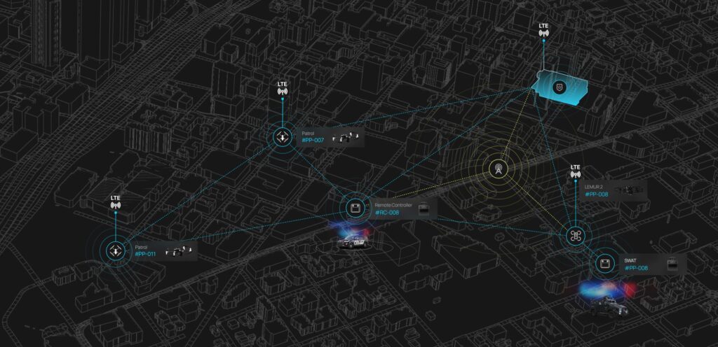
Responder retains BRINC’s mesh networking system. This means all Responders, Stations and controllers will extend each other’s range. This applies across BRINC’s entire ecosystem, so Responders can extend the range of Lemur 2s. If a Lemur 2 is indoors and Respond is overhead, Responder can act as an aerial repeater, dramatically extending the range of the Lemur 2.
Coverage can be further expanded with additional stand-alone repeater sites throughout a community to guarantee connectivity.
Powerful Cameras for Informed Decision Making
The gimbal payload on Responder includes a powerful zoom camera and a high resolution thermal imager. The zoom camera uses two different camera sensors with different lenses, optical zoom and some sophisticated software to digitally blend or switch between cameras depending on the needs of the situation.
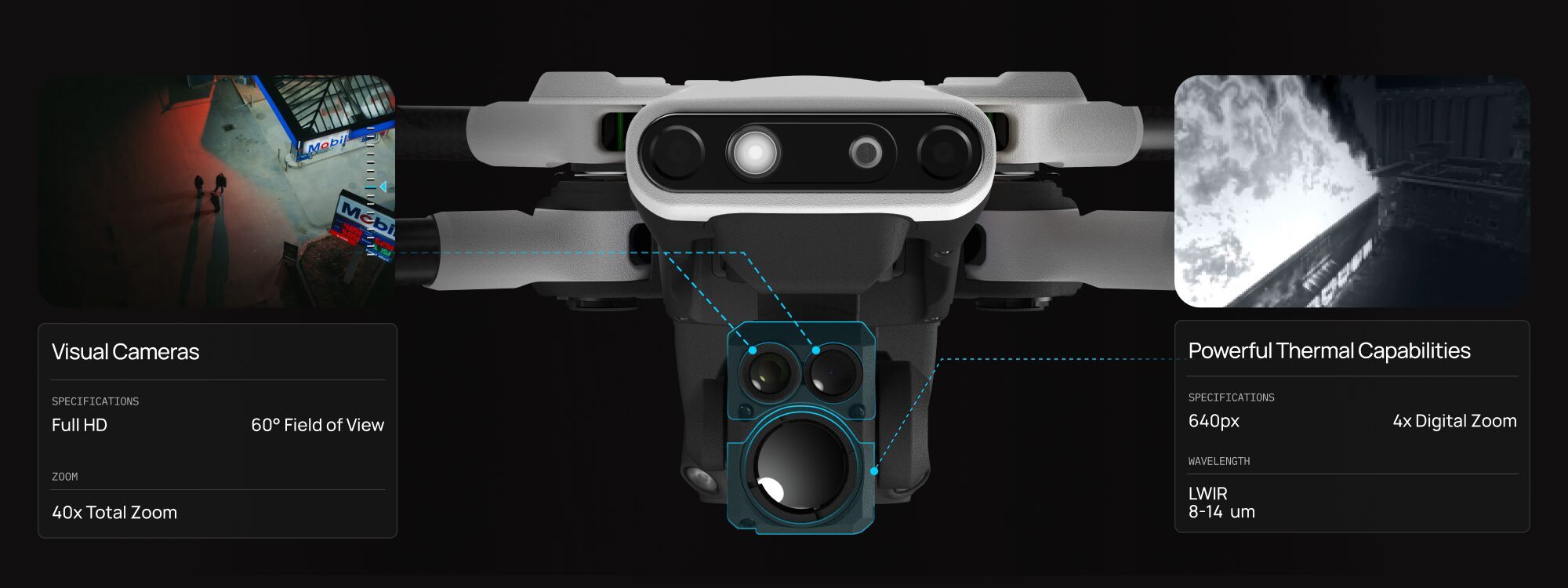
The thermal camera on Responder has a 640 px resolution to visually identify temperature differences, even in low or no light conditions. Being able to see temperature makes it easy to locate hot spots during structure fires, find lost or injured individualsheat signatures and gather other crucial intelligence.
Communicate in High Risk Situations
Responder has an industry-leading two-way audio system, now enhanced with a powerful siren audible up to 800 feet away. This feature enables users to communicate their presence, deliver instructions, or help de-escalate potentially dangerous situations more effectively.
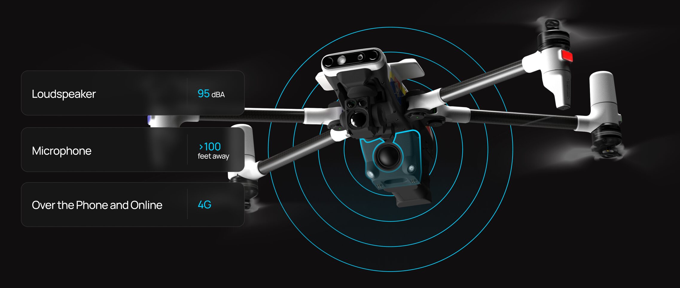
Activation of the loudspeaker can be done by simply calling the drone’s dedicated cell phone number or via LiveOps, ensuring flexibility and ease of use during critical operations.
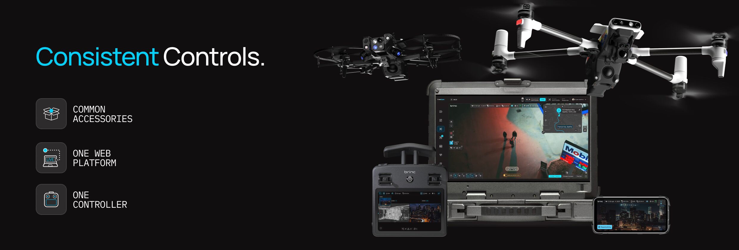
Common Controller and Accessories
Lemur 2 and Responder share a common controller, charger, accessories, mesh radios, software, and more. With BRINC you do not have to worry about managing a dozen different drones, chargers, controllers, software vendors, etc. You can standardize on a single solution, get fully trained and focus on the mission.
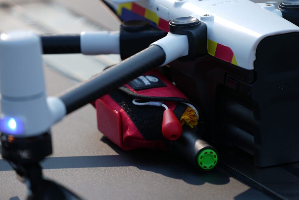
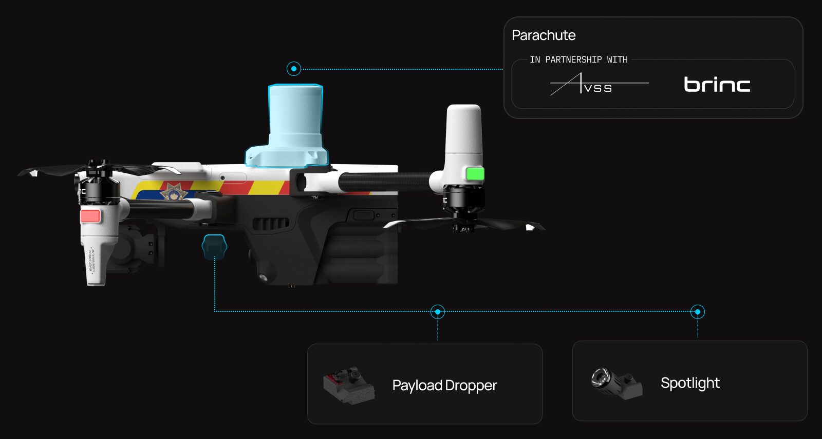
Attachments for Advanced Operations
We built Responder with modularity in mind. The drone has the same attachment rail as Lemur 2 and can be equipped with a dropper or spotlight. Responder also has a mounting point for an emergency parachute system to improve safety in city based deployments.
Emergency Deliveries
When Responder is deployed in cities, life saving supplies can always be made available within 90 seconds. The drone is capable of delivering EpiPens, Narcan, AEDs, PFDs and more.
Intelligent Autonomy Systems
Responder is equipped with a range of advanced sensors and illuminatorslights to enhance its functionality, safety, and ease of use in various conditions.
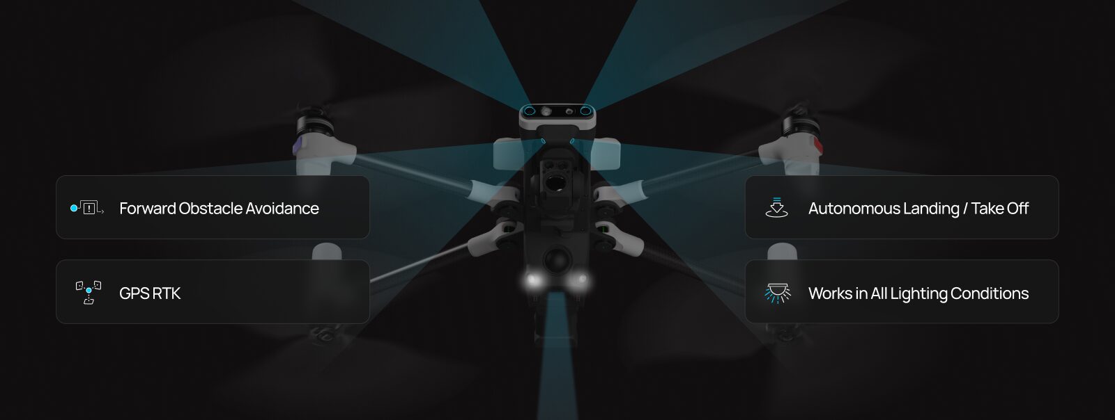
These features collectively make Responder an intelligent, autonomous, and upgradeable platform capable of precise operations. Here’s a closer look at each feature and its role in the system:
Front Facing Obstacle Avoidance Sensors: These sensors help Responder detect and navigate around obstacles in its path, improving safety and reliability in complex environments.
GPS RTK (Real-Time Kinematics): This technology enhances GPS data accuracy, providing centimeter-level positioning which is crucial for precise operations like mapping.
Multiple Redundant Tracking Cameras and LiDAR: These sensors offer additional layers of flight stability by providing multiple visual feedback streams, ensuring reliable navigation and assisting in autonomous landings in Stations.
Integrated Lighting Systems: Downward facing lighting turns on when landing to ensure the cameras have enough light to detect the ground or to see the landing markers in Station.
Portable Design
The Responder drone features a portable design, utilizing lightweight and durable materials to facilitate easy transportation. Its arms and props can be swiveled to reduce its size, allowing it to fit snugly into a compact case, making it an ideal choice for rapid deployment in the field.
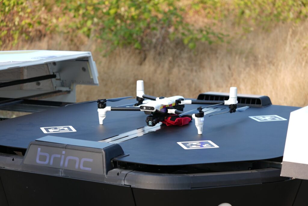
Responder Station
Today, we are excited to announce another significant piece of hardware: Responder Station – a robotic drone recharging nest for Responder.
Designed to be mounted at police and fire stations or other strategic locations within a community, the Station charges, protects, and deploys the Responder drone. Tailored specifically for DFR operations, it is capable of launching drones to emergencies in less than five seconds.
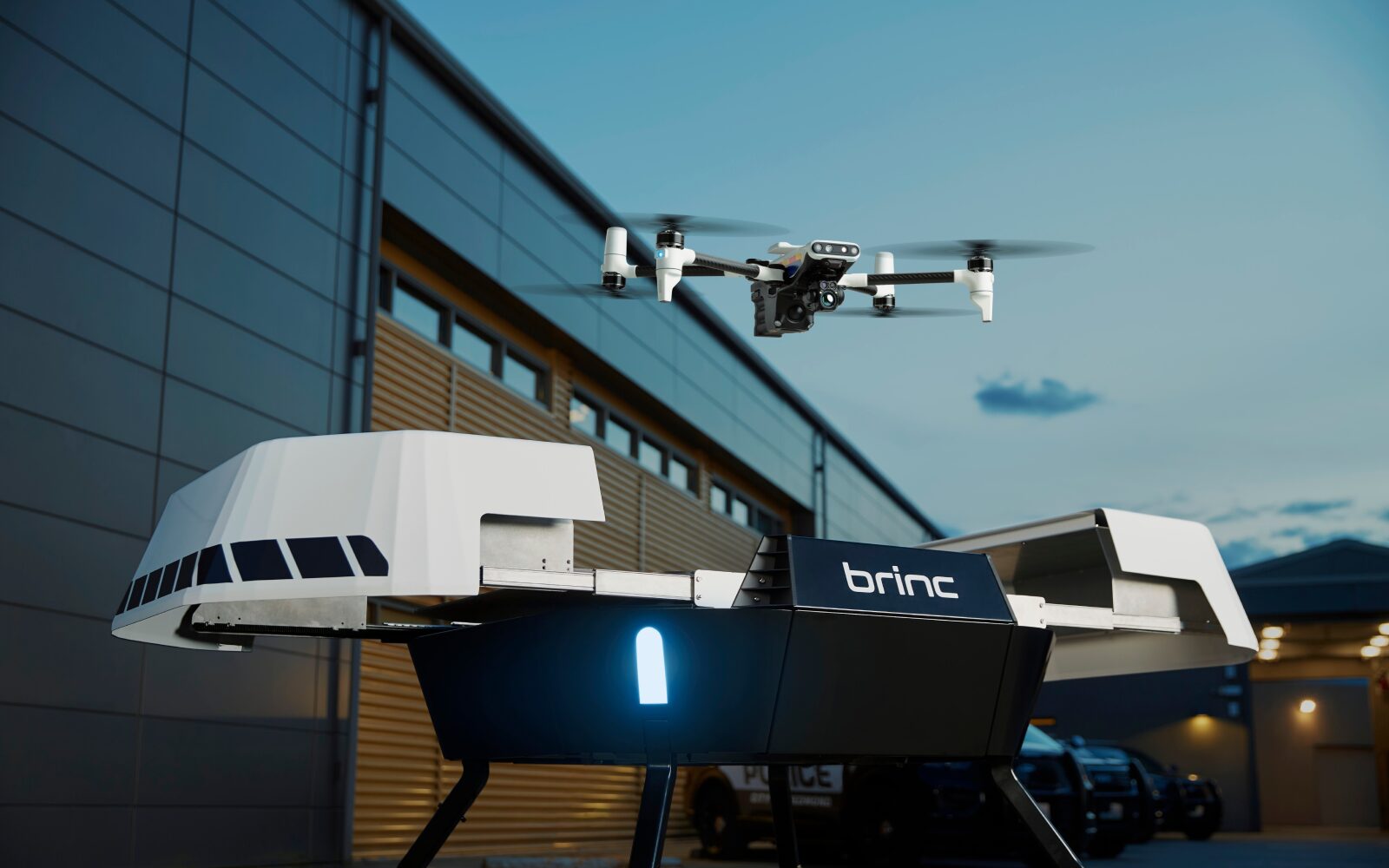
Station is built to withstand extreme weather conditions, ensuring reliable performance no matter the environment. Its installation is straightforward, requiring only an ethernet connection and a 110V outlet.
Additionally, Station can be mounted on large vehicles or set up in remote locations, utilizing Starlink and solar panels for enhanced connectivity and energy independence.
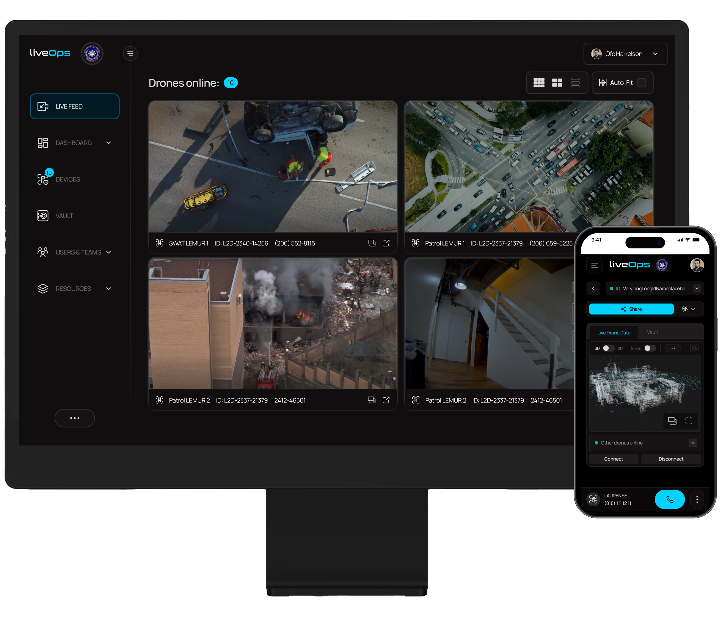
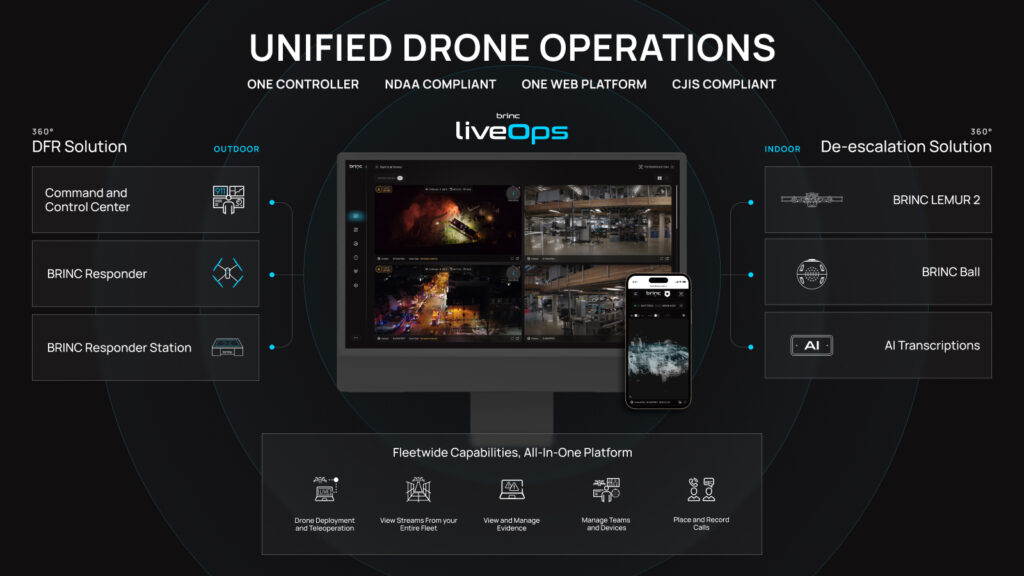
LiveOps: Unified Drone Operations Software
BRINC DFR is driven by LiveOps, a drone operations software platform available on all modern web browsers. This allows for easy access on mobile devices, tablets, mobile data computers, and at real-time crime centers.
Teleoperations
Operate Station and Responder directly from LiveOps from anywhere in the world using just a browser tab and your arrow keys. LiveOps enables district-wide deployments by displaying calls for service and available drones, selecting a Station to launch from, and quickly deploying Responder drones to emergencies.
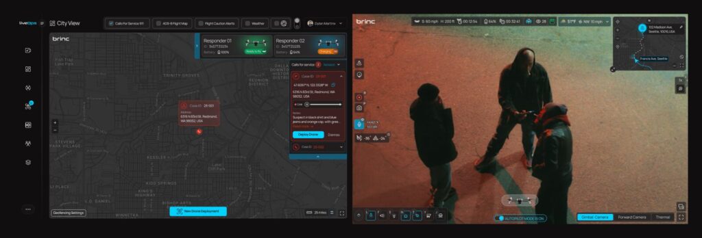
More than just remote piloting, LiveOps allows for the control of Responder’s payload dropper, spotlight attachment, and 2-way audio system.
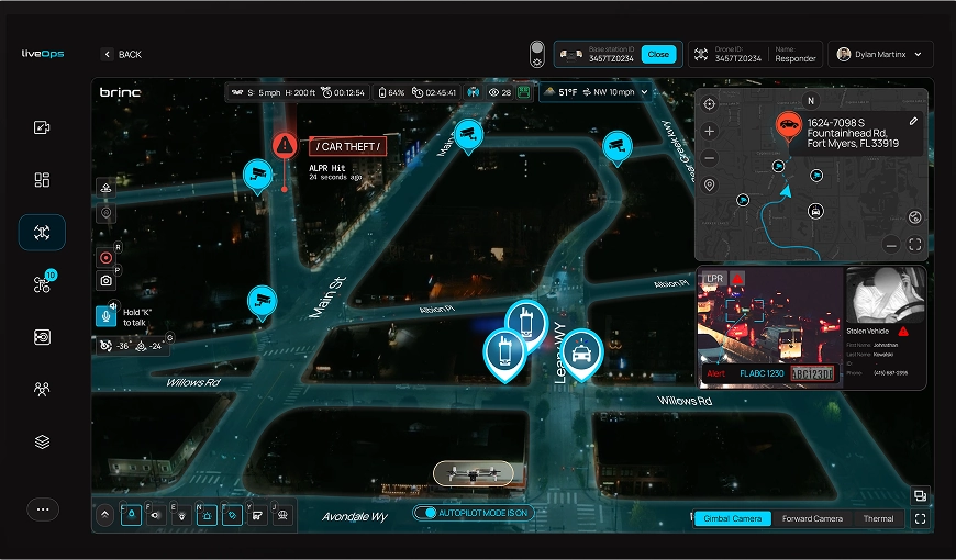
Augmented Reality Overlays
LiveOps now supports augmented reality overlays on drone video feeds. This functionality superimposes street names directly onto the actual streets in the video feed, displays columns of light to indicate call for service locations, and can integrate with body camera GPS positions to show the locations of officers on the ground.
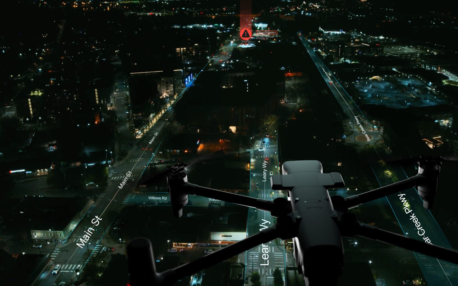
This enhancement greatly simplifies the communication of details to units on the ground, improving coordination and response efficiency.
Integrations
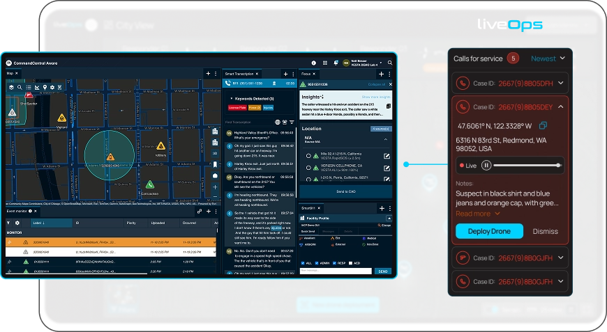
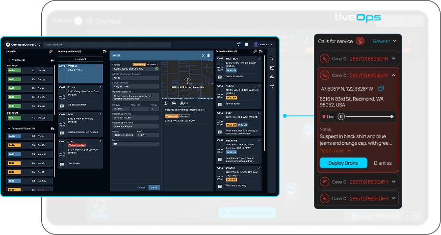
The most powerful aspect of LiveOps is its ability to be integrated with a wide variety of pre-existing public safety systems, making the implementation of BRINC DFR straightforward. At launch, LiveOps is integrated with Live911, which provides 911 call locations and allows teleoperators to hear live 911 call audio to improve situational awareness.
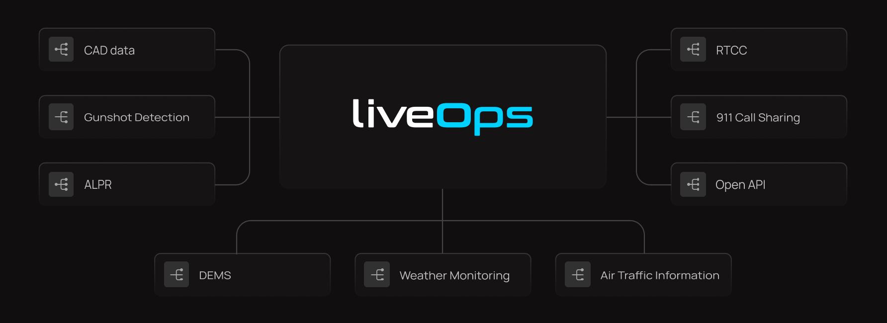
LiveOps can also receive call-for-service locations directly from CAD systems, making DFR deployments even quicker.
Additionally, LiveOps has the capability to instantly stream video to Real-Time Crime Centers (RTCC) and can coordinate the deployment of drones in response to specific incidents, such as gunshot detections or automated license plate recognition (ALPR) alerts.
All drone footage can be seamlessly uploaded to Digital Evidence Management Systems (DEMS). This integration facilitates efficient archiving, retrieval, and management of video data, ensuring that all footage is easily accessible and securely stored.
Critical weather data is also displayed to ensure the safety and efficiency of drone operations. This feature allows operators to monitor real-time weather conditions, including wind speeds, precipitation, and temperature, which can significantly affect drone performance.
LiveOps enhances safety by displaying Automatic Dependent Surveillance-Broadcast (ADS-B) data, providing real-time locations of nearby crewed aircraft. This feature allows teleoperators to maintain situational awareness and manage airspace effectively.
Together, these features create an integrated response system that improves the overall efficiency and effectiveness of DFR operations.
BVLOS Without a VO
A significant barrier to DFR operations historically has been the FAA regulatory requirement for a visual observer (VO) on beyond visual line of sight (BVLOS) missions. This requirement necessitates having a person, typically positioned on a rooftop, actively scanning for manned aircraft to prevent collisions.
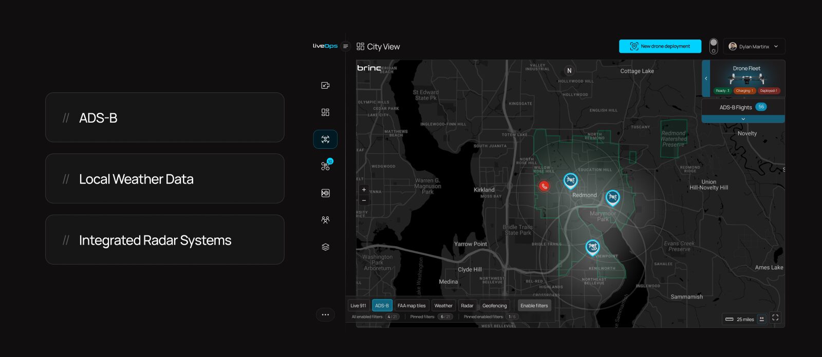
This adds cost and complexity to DFR deployments due to the additional staffing requirement. However, a promising solution exists. LiveOps integrates data from ADS-B and ground-based radar systems to detect nearby aircraft and strategically reroute drones to avoid them.
BRINC is working to enable operations without a VO using this technology. We have partnered with Echodyne, a leading radar manufacturer, to achieve this. This development will significantly broaden the accessibility of DFR technology to nearly all agencies.
Built With Communities in Mind
We believe that DFR will be a tremendous social good, and save many lives. However, we are aware this is a powerful technology, and we have designed it with communities in mind. In pursuit of this goal, BRINC has made a commitment against weaponizing our products.
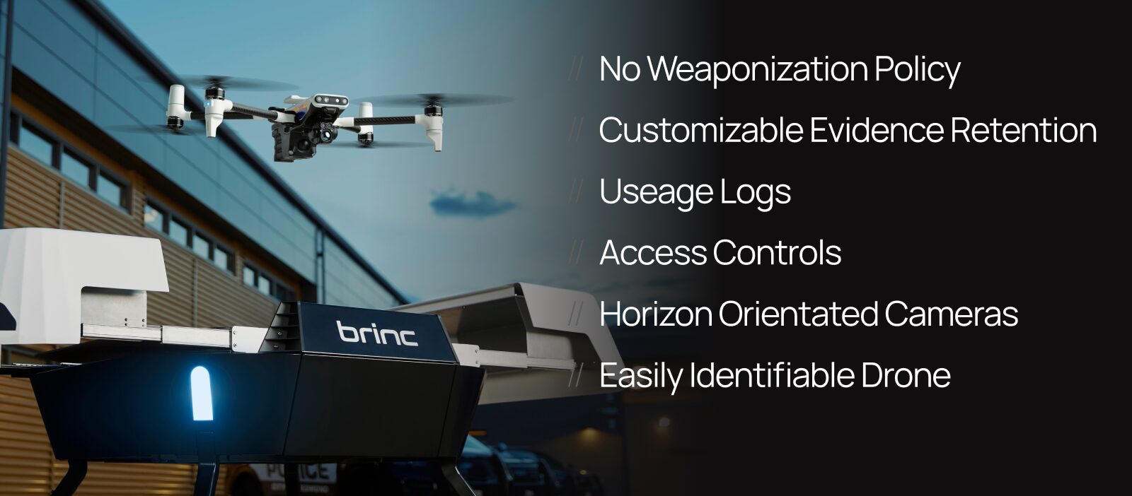
In addition, we have developed a suite of tools designed to help agencies effectively manage their DFR programs. These tools include configurable data retention settings and usage logs that link pilots to specific missions, as well as automated camera adjustments that swivel the drone’s gimbal to neutral positions during flights to and from emergencies.
Additionally, our drones are also easily identifiable as public safety vehicles, ensuring transparency. We are dedicated to ensuring that this technology provides significant benefits to the communities where it is implemented, and that it is used responsibly.
Public Transparency Portal
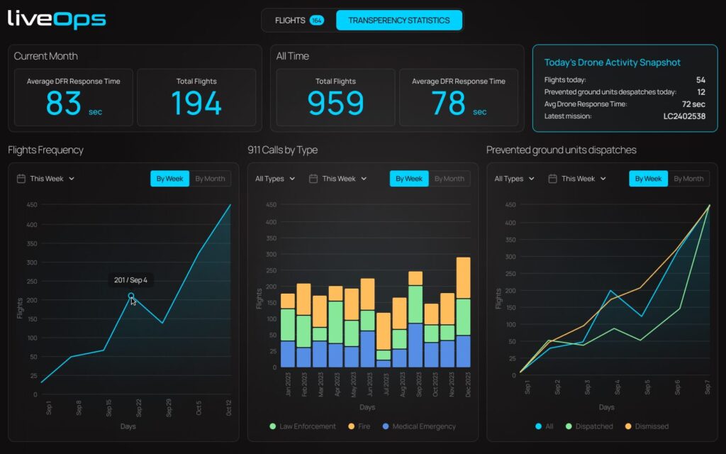
We have also developed a public transparency portal to enhance community understanding of DFR operations. This portal displays program statistics, such as the number of DFR flights conducted, average response times, and the types of emergencies most frequently addressed by the drones.
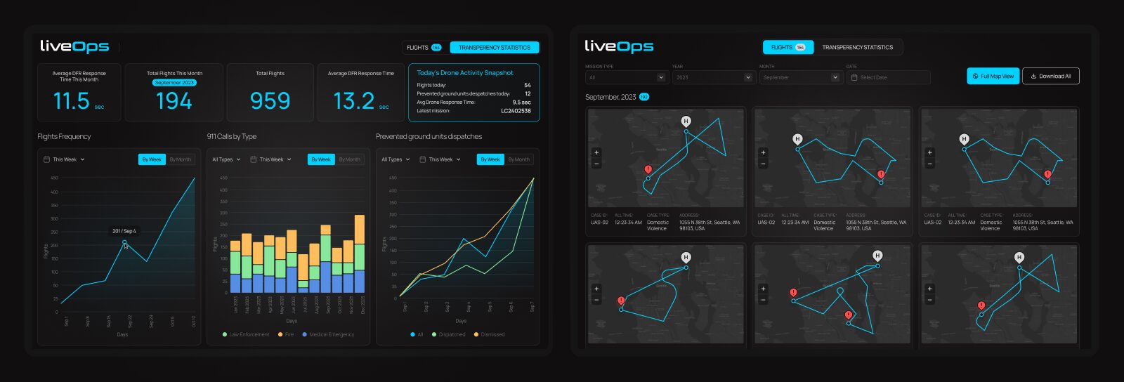
The transparency portal also provides historical flight paths and the specific purpose of each mission. If community members are curious about the presence of an emergency response drone, they can easily access the portal to view detailed information about the flight’s purpose, launch time and flight path for greater transparency.
Built with Security in Mind
BRINC technology is meticulously designed with robust security measures at its core. All our hardware is NDAA compliant, ensuring that no silicon or sensors are sourced from China—a significant achievement given that the global drone supply chain is based in China.

Despite these challenges, we have successfully localized production, with all hardware assembled at our headquarters in Seattle, WA. Additionally, LiveOps is CJIS compliant, hosted on AWS servers in the U.S., and all data is encrypted to safeguard information integrity and privacy. At BRINC, we prioritize security to the highest degree, reflecting our commitment to delivering safe and reliable American technology solutions.
BRINC Safeguard
Our technology is available to purchase à la carte or through BRINC Safeguard, which offers comprehensive hardware upgrades, replacements, software, support, COA services and more. With Safeguard, partners receive automatic upgrades to the latest BRINC hardware upon release, unlimited replacements for drones that are damaged or destroyed, LiveOps licenses, and complete Station installation and maintenance.
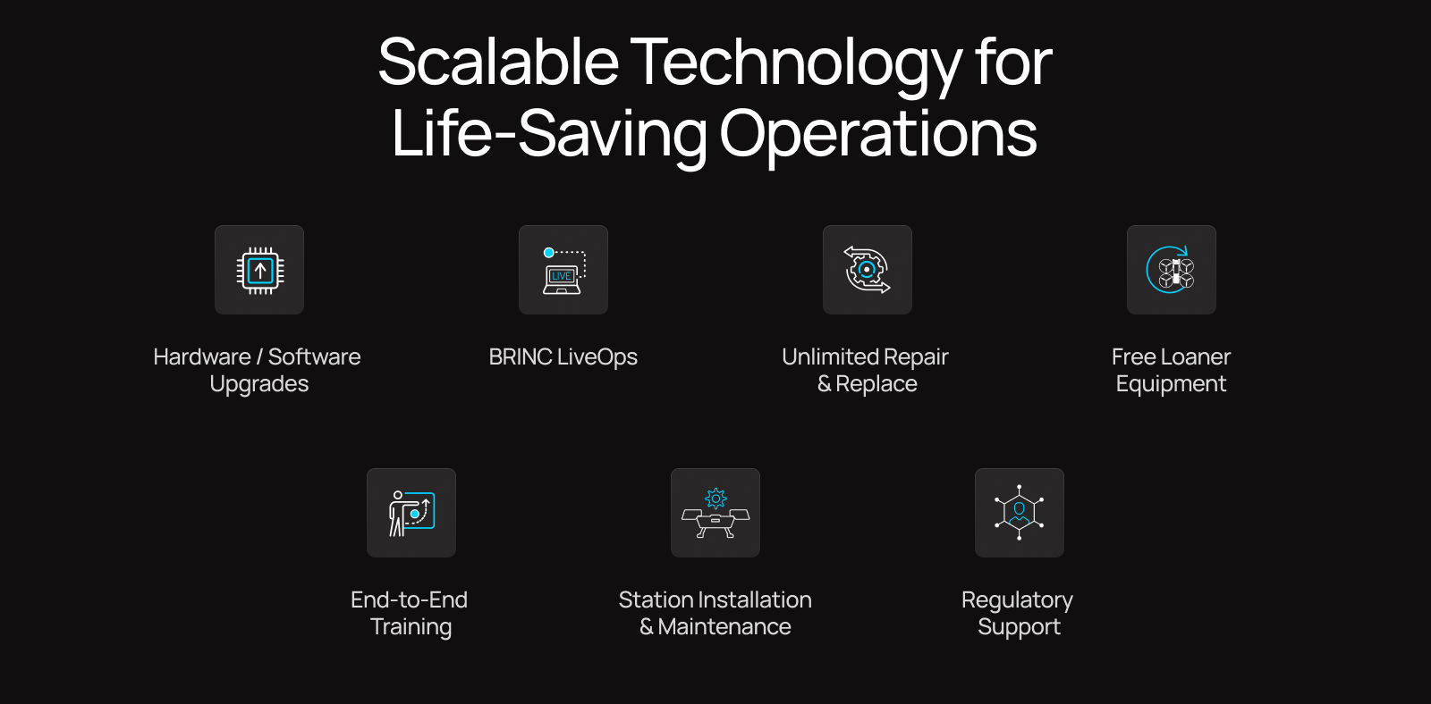
The Safeguard program also provides regulatory assistance – such as help with applying for COAs and BVLOS waivers. This comprehensive service ensures that agencies can establish and maintain a drone program with budgetary certainty. Safeguard is an excellent way for agencies to partner with us, providing them with a seamless and efficient solution for integrating drone technology into their operations.

Today, we’re thrilled to unveil the full capabilities of LiveOps, a cutting-edge software platform designed for first responders. LiveOps integrates with the BRINC hardware ecosystem, including LEMUR 2, BRINC Ball, and future drones, to provide teams with a unified platform for live streaming drone video feeds, communicating during crisis situations, storing evidence, and managing drone operations. Below we’ll cover some of the key capabilities of LiveOps.
Multi-Drone and Multi-Camera Live Streaming
BRINC devices integrate seamlessly with the LiveOps platform to instantly live stream LEMUR 2 camera feeds to the entire team, viewable on any internet-connected device. Operators can easily toggle between various camera feeds – visual, thermal, and 3D maps – regardless of what the pilot is seeing, allowing for customizable views depending on each mission. This works beyond a single drone, with LiveOps users being able to arrange all connected BRINC drones to be viewable on a single screen.
Access Real-Time Floor Plans
The real-time maps feature on LiveOps utilizes LEMUR 2’s LiDAR sensors – lasers to measure distances to objects and surfaces – to continuously gather data as it flies and scans, creating detailed 3D maps. These maps update in real-time during flight and can be converted to 2D floor plans using the Slicer tool, helping to document and get an understanding of the layout of a structure during or after a mission.
Real-time floor plans are built to streamline tactical workflows:
Informed Before Entry – Gain a clear understanding of the area layout before deploying officers to make entry.
Streamlined Post-Action Reports – Cut time spent manually drawing floor plans while improving accuracy.
Emergency Planning with Saved Floor Plans – Quickly access digital floor plans from past scans by address or map view.

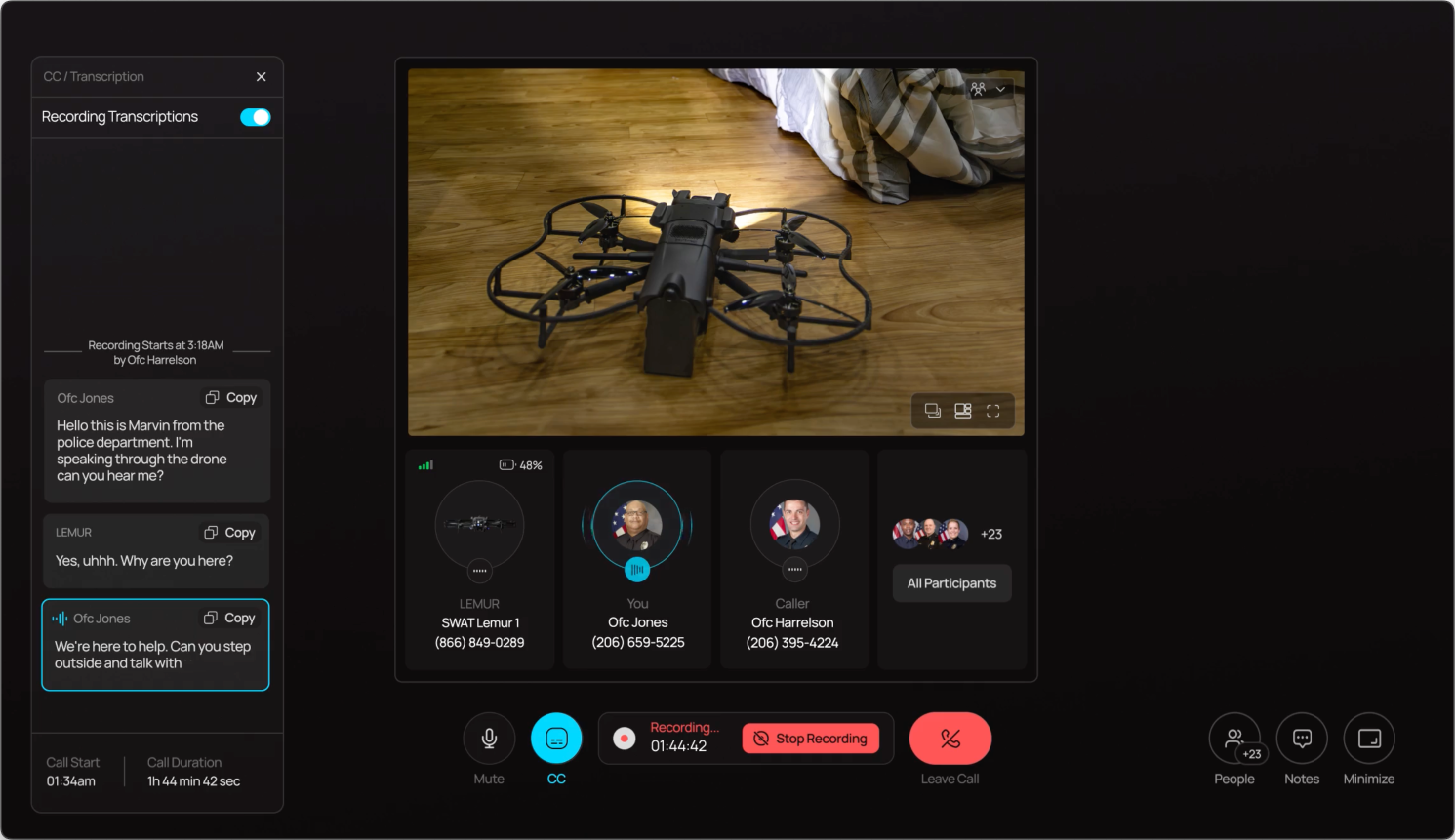
Place and Record Calls
LiveOps facilitates two-way communications with external cell phones or BRINC devices, aiding in de-escalation efforts. With LiveOps, users can initiate calls and add additional participants directly from their browser. Additionally, through LiveOps users can record calls for better documentation during critical negotiations.
AI-powered Call Transcriptions
LiveOps provides real-time, AI-powered call transcriptions during missions, assisting negotiations and personnel briefings. If calls are recorded, a second AI analysis refines transcription accuracy and enables additional features like translation, saving time in the prosecution stage.
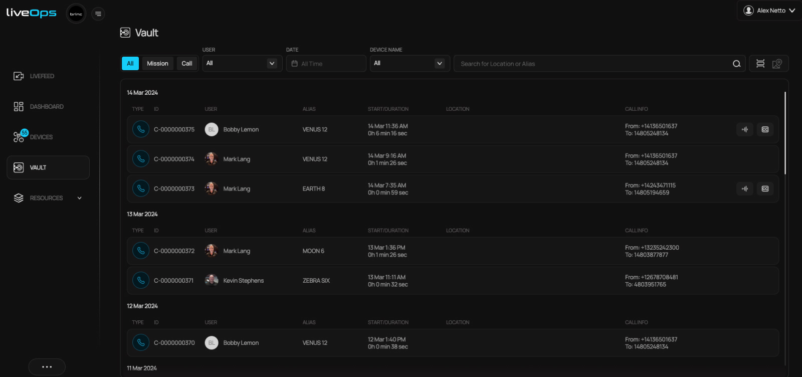
BRINC Vault Evidence & Data Storage
LiveOps serves as a post-mission database for call history, call recordings, call transcriptions, 3D maps, flight logs, drone footage and more. With BRINC Vault, teams can securely access mission-critical data, supported by CJIS-compliant logs for evidence integrity. LiveOps provides efficient evidence storage and management, ensuring data accessibility when needed.
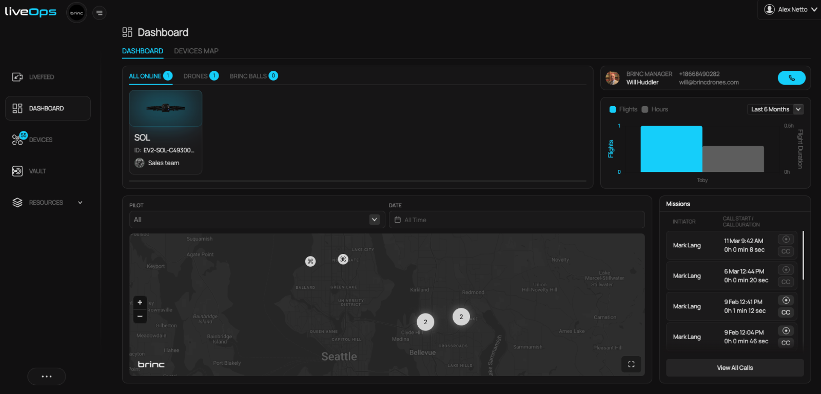
Team & Fleet Management
LiveOps scales with your drone program, streamlining the management of additional devices and users. LiveOps offers team management of pilots, hardware tracking, and essential operational tools like flight logs, device location maps, and mission logs.
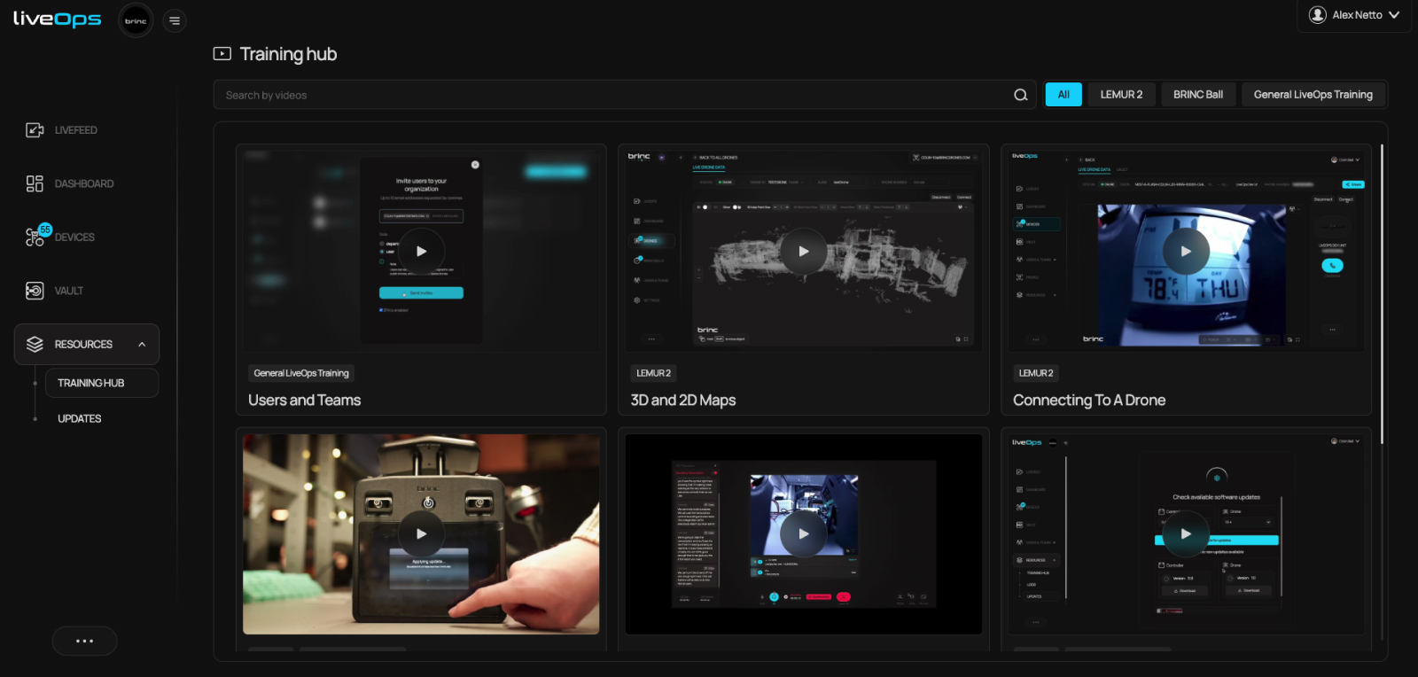
Training & Software Updates
The LiveOps resources section provides quick access to training videos, quickstart guides, and various ‘how-to’ product videos. Additionally, the software update portal is readily available within this section, enabling the management of both controller and drone firmware.
Security
LiveOps has FIPS 140-2 encryption for both data in transit and at rest, ensuring the integrity of your mission data. Data is securely hosted on AWS servers within the U.S., adhering to domestic data residency requirements. LiveOps is CJIS compliant, meeting FBI standards for managing criminal justice information, ensuring secure data handling.
Public API
Integrate LiveOps into your agency’s existing technology infrastructure. Whether it’s integrating data from Computer-Aided Dispatch (CAD) or automatically sending evidence to your preferred Digital Evidence Management System (DEMS) platform, LiveOps enables connection with your systems.
You can learn more about BRINC LiveOps and how it can help your agency at our dedicated LiveOps page here, or contact a BRINC representative below.
Launching or scaling a drone program demands careful consideration and planning. With drones playing an increasingly vital role in public safety and emergency response, agencies must carefully evaluate numerous factors to ensure effective implementation.
These factors range from addressing privacy concerns and ensuring regulatory compliance to selecting the most suitable equipment among various options. In this blog, we explore critical considerations and recommendations for agencies looking to establish or expand their drone programs.
Table of Contents
- Privacy Concerns and Transparency
- Regulations and Policy
- Budgeting and ROI
- Cybersecurity Concerns
- Integration with Public Safety Operations
Privacy Concerns and Transparency
In the development of a drone program, early community engagement is essential. This helps address pressing concerns about public trust, civil liberties, and the public’s right to privacy.
Proactively reaching out to community organizations, jurisdictional leadership, the media, and other relevant stakeholders is crucial. It helps in formulating policies and operational guidelines with full transparency. This requires maintaining a consistent and open communication channel. The aim is to address any evolving concerns associated with city-wide drone implementation and operations.
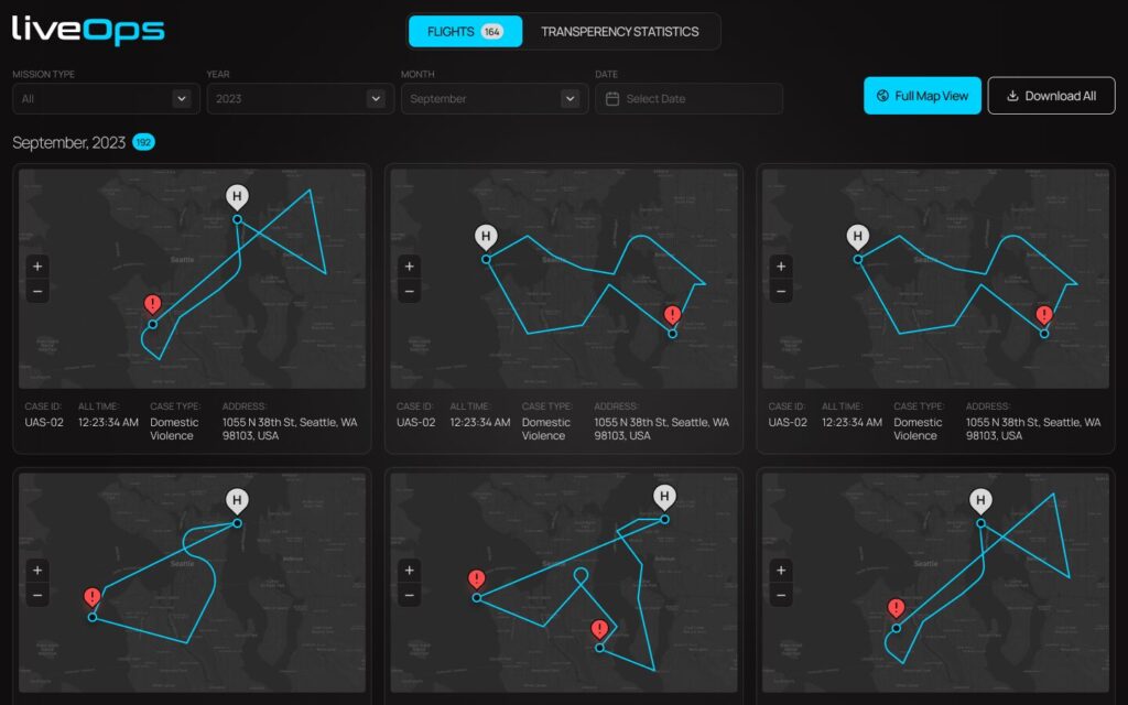
Maintaining a public record of daily flights is crucial for agencies. This record should include details such as the purpose, location, flight telemetry, date, and time of each flight.
This measure enables community members to easily access information about why a public safety drone is in the area by referring to the agency’s website. Furthermore, it’s advisable to have an analytics dashboard. This dashboard can track the frequency of drone deployments during emergencies and their role in arrests.
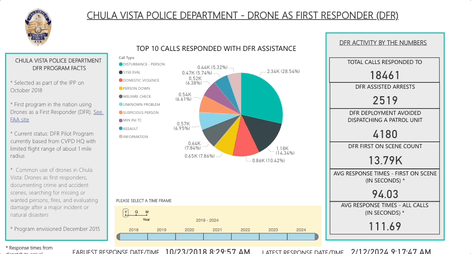
Early Example – CVPD’s Transparency Dashboard
In the Chula Vista Police Department’s (CVPD) drone as first responder (DFR) program, which utilizes drones to promptly respond to emergencies upon receiving a call for service, a notable contributor to the program’s success and its city-wide adoption is their transparency portal.
The program’s mission is to provide airborne support to police operations in a safe, responsible, and transparent manner, aiming to preserve the peace, reduce response times, and enhance the quality of life in Chula Vista. Find out more about why agencies are implementing DFR programs.
Regulations and Policy
Drone operations are governed by FAA regulations and may also be influenced by state and local ordinances. As such, agencies contemplating the adoption of drones (UAVs) must possess a comprehensive understanding of FAA waivers and the requisite legal operational standards.
To legally pilot drones, individuals can acquire certification through the FAA’s Aeronautical Knowledge Test. Upon successful completion, each participant is awarded a Remote Pilot Certificate (FAA Part 107), a foundational step for both trialing drones and initiating a program.
It is worth noting, however, that this certification comes with specific flight limitations and restrictions to include flights within visual line of sight (VLOS), operations at night, operations of a single aircraft, and operations over people and vehicles.
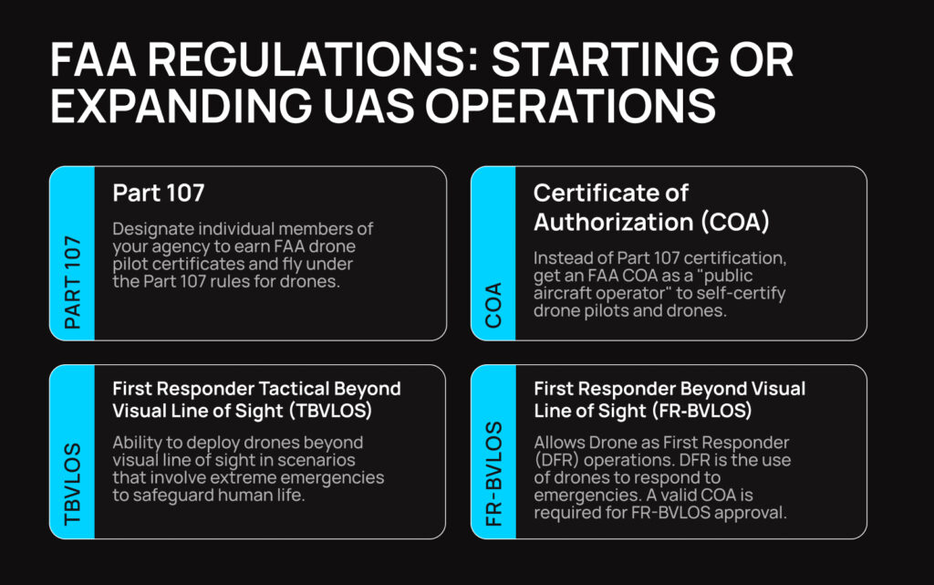
For a more flexible operational scope, agencies can pursue the FAA Part 91 Certificate of Authorization (COA). This certification empowers public safety drone programs to set their own standards and implement the necessary evaluations for members to attain drone pilot status. Although obtaining a Part 91 COA is a more extensive process, it affords pilots a broader range of flight permissions.
TBVLOS, or Tactical Beyond Visual Line of Sight, waivers enable first responders to operate unmanned aircraft systems (UAS) in critical emergencies, such as fires or search missions, where human life is at risk. The FAA grants these waivers under specific conditions. These conditions include the requirement for a valid Part 91 COA, limitations on altitude and proximity to obstacles, and the necessity to revert to visual line of sight operations when practical.
FR-BVLOS, or First Responder Beyond Visual Line of Sight, waivers enable DFR operations, marking a significant advancement in public safety drone programs. DFR involves drones swiftly responding to emergencies upon receiving a call for service, delivering vital information to enhance response efforts. To be approved by the FAA, an agency must possess a valid COA, adhere to altitude and obstacle proximity restrictions, and revert to visual line of sight operations when possible.
Budgeting and ROI
Establishing a drone program demands foresight, patience, and concerted effort. Crafting a long-term strategy to sustain your agency’s drone program is pivotal for enduring success. In exploring the benefits of UAS, a shift towards data-driven analysis offers a compelling perspective on return on investment (ROI).
Collaborating with UAS providers to customize programs tailored to public safety needs enables the quantification of efficiencies, reduction in manpower, and optimized resource allocation.
UAS operations have the potential to minimize overtime expenses while expanding law enforcement capabilities at a fraction of traditional costs.
Ultimately, integrating UAS into public safety isn’t just about adopting technology—it’s about maximizing ROI through intelligent decision-making and resource management, while enhancing public safety.
Cybersecurity Concerns
As drone programs expand, the amount of information collected and stored by drones and associated software will increase significantly, encompassing various aspects of our towns, cities, and other regions.
This necessitates a careful approach in vendor selection and data storage protocols to address cybersecurity risks effectively. These risks can be divided into three main areas: data in transit, data at rest, and data governance.
Data in transit involves the information transmitted between devices, such as between the drone and its operator. It’s crucial that all data transmitted is encrypted end-to-end to prevent unauthorized interception and access.
AES-256 encryption is essential for secure drone-to-operator communication, providing robust protection with its 256-bit key, ensuring confidentiality and integrity during data transmission.
Data at rest pertains to the data stored within a device. Measures must be implemented to ensure that access to storage mediums like SD cards is safeguarded through password protection and physical security measures.
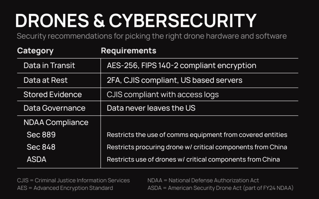
Data governance is essential, with trust in chosen vendors paramount for agencies. It’s crucial to ensure data remains within the country and that software is Criminal Justice Information Services (CJIS) compliant, adhering to FBI security standards for storing, transmitting, and accessing criminal justice information.
Maintaining software development free from influence by foreign entities is imperative to mitigate data security risks.
Additionally, NDAA compliance and supply chain security play a vital role in bolstering supply chain security, ensuring crucial drone components are not sourced from covered foreign countries or companies.
Federal policy restricts taxpayer funds for purchasing drones from Chinese-based companies and encourages the adoption of domestically produced UAS. This stance is echoed by federal departments, including the Departments of Interior, Justice, and Homeland Security, with many states implementing their own regulations on untrustworthy drones for state or local agencies.
Integration with Public Safety Operations
Drones should not be viewed merely as standalone equipment but as integral components of a comprehensive UAS program. Their applications, including outdoor overwatch, indoor tactical response, mapping, and DFR operations, have already proven invaluable across various jurisdictions.
A thorough evaluation of agency-specific needs is essential, followed by seamless integration of UAS operations into established law enforcement, firefighting, and EMS protocols.
An essential evolution involves embedding drone functionality into core emergency response strategies. By thoroughly integrating drones into routine operations, agencies can develop a deeper organizational understanding of their capabilities. Such integration efforts should involve diverse stakeholders, ensuring a robust outcome with widespread internal support.
Having a platform to manage, organize, and operate a drone program is paramount to success. Integrating with BRINC LiveOps, a cloud-based platform streamlining drone program operations, offers a comprehensive set of features to enhance UAS operations seamlessly.
From viewing live streams and 2D floor plan data to facilitating communication and teleoperation, LiveOps provides the tools needed to manage fleets, track operations, and maintain transparency with the community in real-time. Moreover, LiveOps is robust enough to integrate into existing agency software solutions for a seamless integration, including CAD and 911 call systems.

Conclusion
In summary, launching or expanding a drone program requires careful consideration of transparency, regulations, budgeting, and integration. Prioritizing transparency, community engagement, and cybersecurity is essential for long term success. Platforms like BRINC LiveOps aid management and integration, ensuring efficiency and innovation in public safety efforts.
If your agency would like the BRINC team to help review your current operations and use our expertise to help aid your program, you can schedule a drone program review.